Cluniac trails in Pays de Serres
Discover the former possessions of the Abbey of St Maurin
The project
Since 1993, the Amis de l’Abbaye de Saint-Maurin have been committed to promoting the Cluniac heritage, which has led to the creation of an itinerary linking several remarkable sites, known as the Guyenne Gascony Cluniac Trail. Today, this route links four major sites: the abbeys of Moissac and Saint-Maurin and the priories of Layrac and Moirax.
But our Pays de Serres is also rich in Cluniac sites. Nearly 80 Cluniac outbuildings have been identified in the Agenais region, including 28 former dependencies of the Abbey of Saint Maurin. By Cluniac sites llinked to the Abbey of Saint Maurin we are referring mainly to the Abbey’s possessions acquired between the 12th and 14th centuries, generally churches or tithe collections. This wealth of the Abbey of Saint Maurin is still reflected today in a remarkable heritage of Romanesque churches and chapels and mills. Find out more about the Abbey’s dependencies.
With this project, the association’s aim is to help walkers, tourists and families discover this heritage, in the form of several trails linked to Saint-Maurin and the Guyenne Gascony trail.
As well as promoting the Cluniac heritage, these trails will be based on the walking routes described by the Lot et Garonne departmental tourism committee, enabling walkers to discover other heritage sites in the Pays de Serres, such as the château de Combebonnet, the church at Engayrac and the mill at Tayrac.
The trail loops
Two hiking trails have been set up:
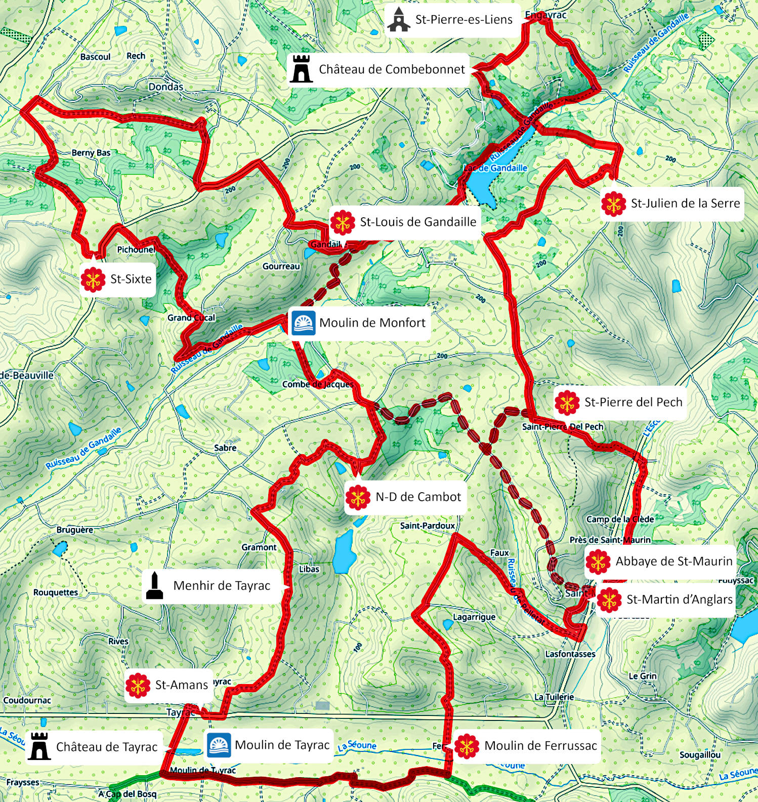
– the central loop, 40km, Saint-Maurin – Engayrac – Dondas – Tayrac – Saint-Maurin
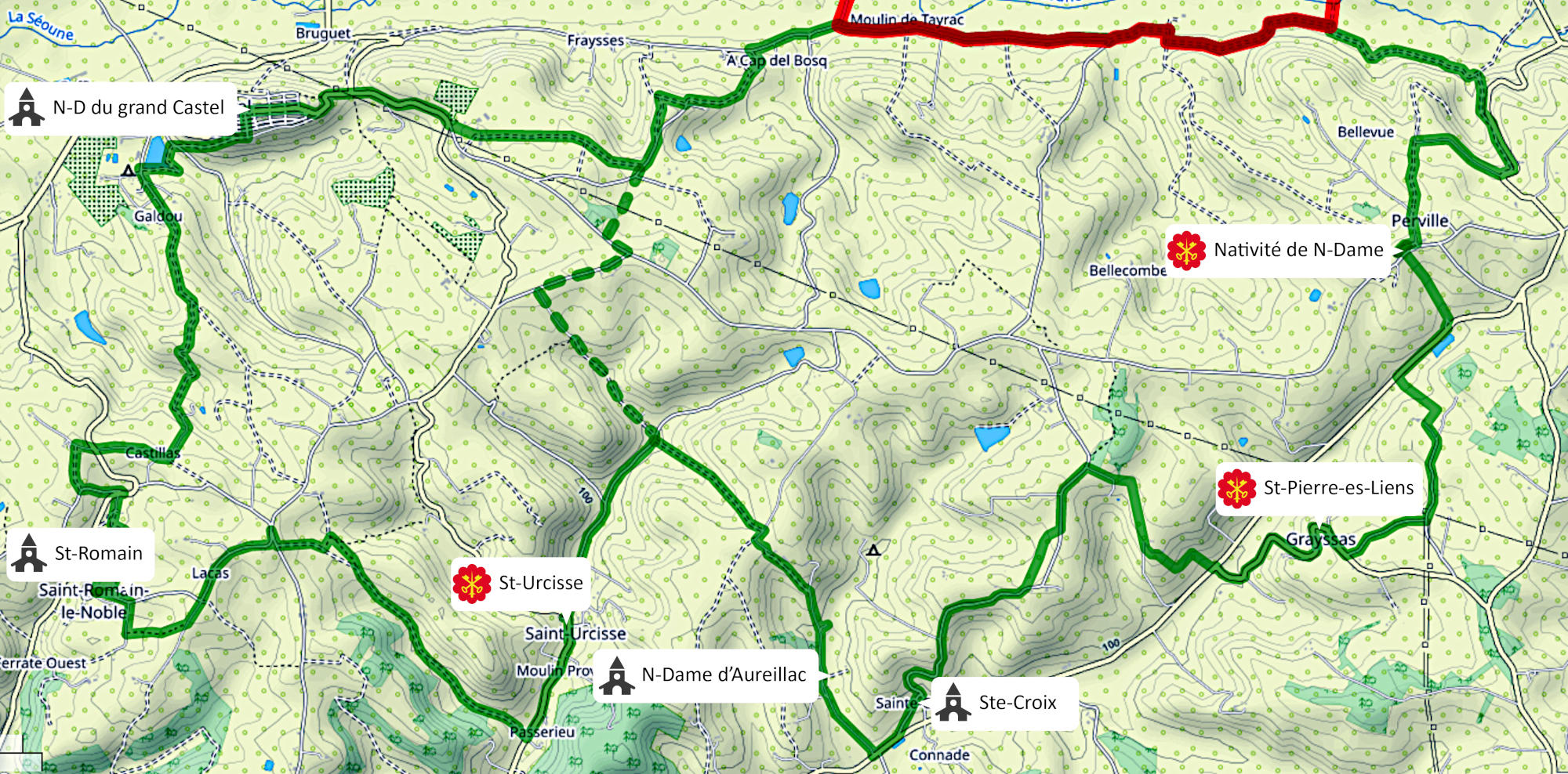
– the south loop, 29km, Puymirol – Tayrac – Perville – Grayssas – St Urcisse – Saint-Romain le Noble – Puymirol.
The Lot-et-Garonne department provided the funding for the site virtual tours and the signage (panels describing the loops, the sites and the directional signs), as our project was the winner of the 2022 Citizen’s Participatory Budget.


The central loop
Starting from Saint-Maurin (or Engayrac or Tayrac), the central loop BCO links 15 notable sites, including 9 Cluniac sites. The full loop is 40km long, with an altitude difference of +1120m. A suggested variant links St-Louis de Gandaille to Notre-Dame de Cambot (cutting out St-Sixte); the total distance of this variant is 30km, with an altitude difference of +820m.
The central loop also offers two clearly marked sub-loops starting from Saint-Maurin:
– starting from ST Maurin or Tayrac, BC1: directly linking St-Pierre del Pech to Notre-Dame de Cambot, this 19km-long loop has a +470m altitude difference.
– starting from St Maurin or Engayrac, BC2: directly linking St-Sixte to Saint-Maurin, this loop is 29km long and has an altitude difference of +840m.

The south loop
Starting from Grayssas (or Perville, Puymirol, Saint-Romain, Saint-Urcisse), the south loop BSO links 7 notable sites, including 3 Cluniac sites. The full loop is 30,5km long, with an altitude difference of +550m.
The south loop also offers two clearly marked sub-loops:
– starting from Puymirol or Saint-Romain or Saint-Urcisse, BS1: directly linking N-D du grand Castel to St-Urcisse, this 15km-long loop has a +260m altitude difference
– starting from Grayssas or Perville, BS2: directly linking the Nativité de N-D to N-D d’Aureillac, this loop is 20km long and has an altitude difference of +360m.
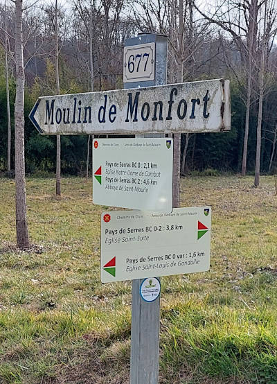
Waymarking and directional signs


Regulations and security
You can find the rules to follow when hiking on the web site of the Fédération Française de la Randonnée Pédestre, especially in page 12 of the memento “Recommandations pour la randonnée sur route”, click here to see the memento
